Modernizing Riga: My Vision for a Digital Twin City
Modernizing Riga: Deep-Diving into the Architecture of a Digital Twin City
The concept of a "Digital Twin" has evolved rapidly from a buzzword in industrial manufacturing to a foundational pillar of modern urban planning. At its core, a Digital Twin is not just a 3-D model; it is a dynamic, living digital reflection of a physical entity—in this case, the historic and vibrant city of Riga, Latvia.
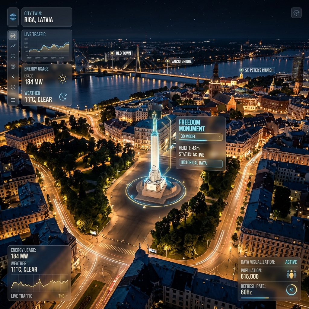
In 2026, we are building more than just a map. We are building a Digital City Infrastructure that synchronizes physical reality with digital precision. This isn't just about rendering buildings; it's about mirroring the heartbeat of a metropolis and creating an "Oracle for Urbanism."
1. The Philosophy of the Mirror: Why Cities Need Twins
For centuries, urban planning was a "Guess and Check" process. Architects drew sketches, built small-scale physical models, and hoped that the final structure would mesh with the city's flow. But cities are chaotic systems. A new skyscraper in the Centrs affects more than just the skyline; it changes wind currents, alters micro-climates, shifts traffic patterns, and impacts property values blocks away.
A Digital Twin solves this by providing a "Safe Sandbox." By creating a 1:1 digital mirror of Riga, we can simulate the impact of every architectural decision before a single cubic meter of concrete is poured. At Bergmanis.com, we view this as the future of "Responsive Urbanism."
2. The Technical Infrastructure: Scaling to a Metropolis
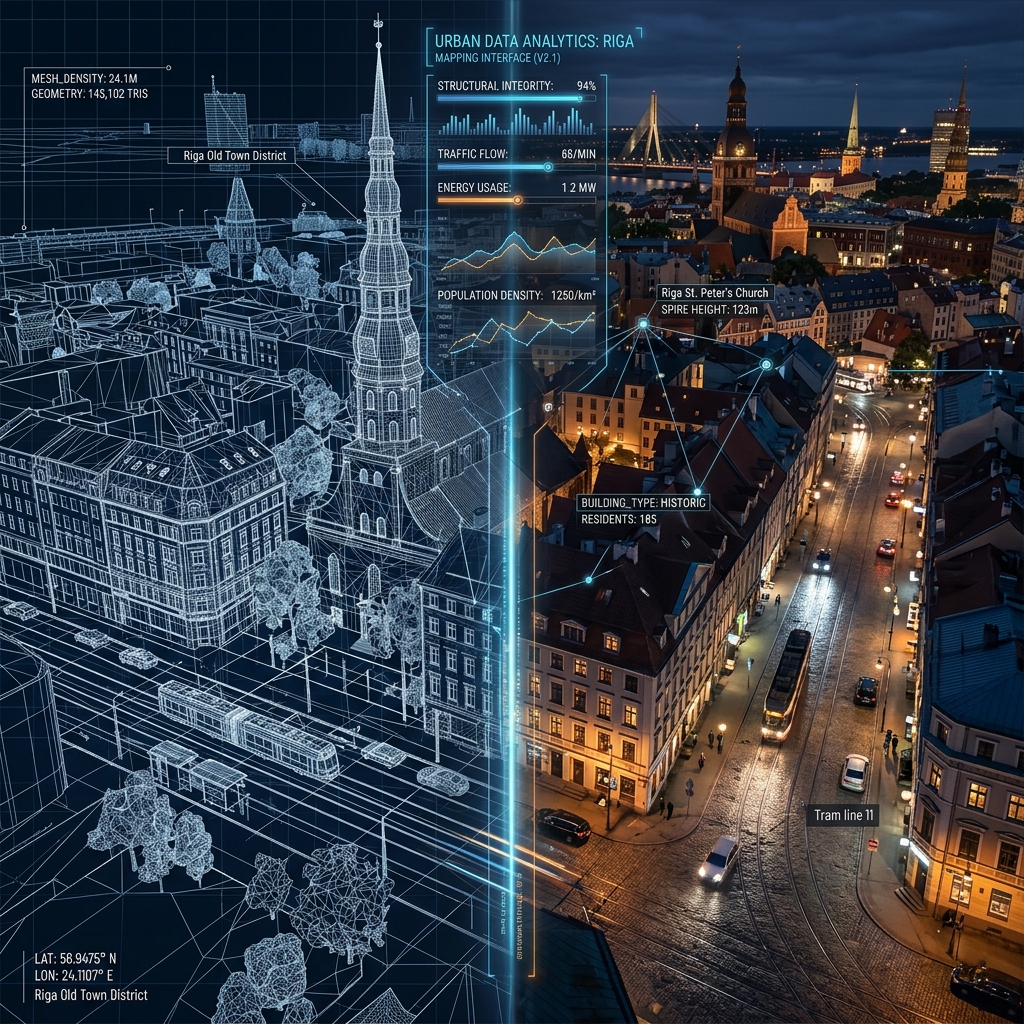
Scaling a 3-D application to cover more than 60 distinct neighborhoods—each with its own architectural character and dense geometry—requires a radical approach to performance and data management.
Performance Comparison: The Great Migration
One of our most critical technical milestones was the migration of our entire 3-D dataset. Historically, web-based 3-D applications relied on OBJ or DAE (Collada) formats. While widely supported, these formats are inefficient for city-scale streaming.| Feature | Legacy (OBJ / DAE) | Modern (Binary GLB) | | :--- | :--- | :--- | | File Structure | Multiple files (.obj, .mtl, .jpg) | Single binary blob (.glb) | | Size (Uncompressed) | 100% (Baseline) | ~30% - 40% (Native Binary) | | Network Requests | High (Multi-file fetching) | Low (Single stream) | | GPU Upload | Slow (requires CPU parsing) | Instant (Buffer-to-GPU) | | Animation Support | Limited | Native and optimized |
The Power of Binary GLB and Draco
In our current architecture, we have standardized on Binary GLB. By utilizing Google's Draco mesh compression, we can transmit complex Art Nouveau facades—like the ornate gargoyles and statues of Alberta iela—at approximately 10% of their original size. This ensures that the history of Riga is preserved in the digital world without sacrificing the "Time to Interactive" for mobile users.3. Spatial Data and GIS Integration: The Geodetic Heart
A 3-D model is just a "game scene" until it is geographically anchored. To transition from a "3-D view" to a "Digital Twin," we integrate deep Geographic Information Systems (GIS) data.
Coordinate Systems and Anchoring
In Latvia, the official coordinate system is LKS-92 (Latvian Coordinate System 1992). To make our twin compatible with global web standards, we perform real-time conversions between LKS-92 and WGS-84 (the system used by GPS and Google Maps).Our primary "Geodetic Datum" or origin point is anchored precisely at the Freedom Monument (Brīvības piemineklis). Every building, street lamp, and tree in our model is synchronized with its physical counterpart to within sub-centimeter accuracy.
Under-the-Hood Infrastructure
The most valuable part of a city is often what you can't see. Our GIS integration allows city workers to "X-ray" the digital streets to see:4. Real-Time Data Pipelines: The Digital Pulse
A Digital Twin must be "alive." This is achieved through real-time data streaming and IoT (Internet of Things) integration. We visualize the city’s data as it happens.
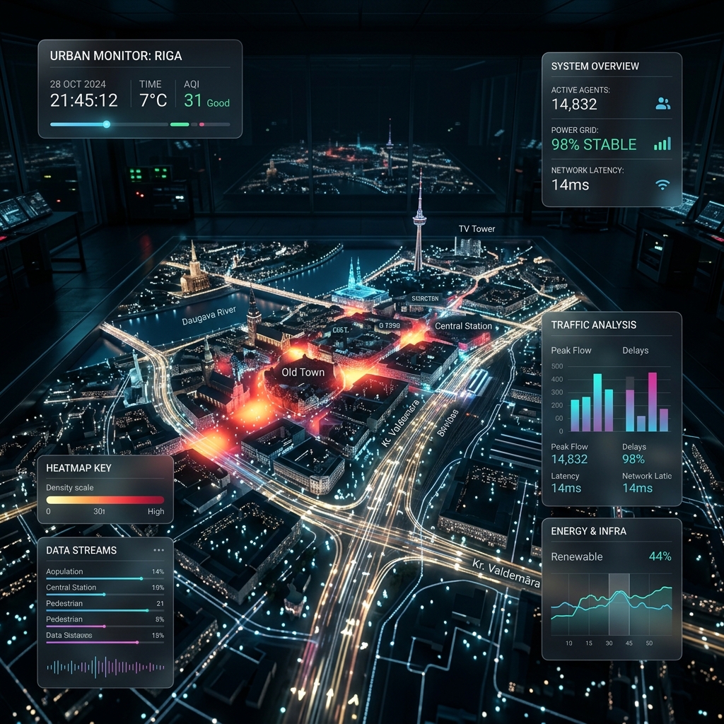
Urban Dynamics and IoT
In 2026, Riga is becoming a "Smart City." We tap into thousands of sensors to create a living dashboard:5. Photorealistic Simulation: The Aesthetic of Immersion
If the twin doesn't look like Riga, users won't trust the data. We use advanced shaders and lighting models to create an immersive experience that feels authentic to our city's unique Baltic atmosphere.
Simulating the "Nordic Light"
Riga’s lighting is unique—from the long shadows of a winter afternoon to the "White Nights" of midsummer.6. The Architect's Sandbox: Predicting the Future
The most powerful use case for the Riga Digital Twin is as a predictive tool. It provides a "Digital Sandbox" where consequences can be measured before they occur.
Urban Resilience and Disaster Response
How would the city handle a 100-year flood of the Daugava? By running hydrodynamic simulations within the twin, we can identify exactly which streets in Bolderāja would be at risk and plan evacuation routes and flood barriers with mathematical certainty.Sustainability and Heat Management
The "Urban Heat Island" effect is a growing concern. Architects use our twin to analyze "Thermal Footprints." By simulating different building materials and the placement of "Green Roofs" or parks, we can quantitatively prove how specific developments will cool or heat the surrounding neighborhood.7. Public Engagement: Democratizing Urban Planning
Urban planning has historically been a top-down, opaque process. The Riga Digital Twin changes this by making the future of the city accessible to everyone.
The "Citizen Scientist" Model
By putting the digital twin on a high-performance web platform, we allow every Rīdzinieks to explore proposed developments. Citizens can:8. Future Roadmap: AR, AI, and Semantic Cities
Our vision for the Riga Digital Twin extends far into the future. Our development roadmap for 2027 and beyond includes:
Conclusion: The Operating System of the City
Building a Digital Twin of Riga is an exercise in both engineering and storytelling. It’s about taking the centuries-old history of our city and projecting it into a scalable, high-performance digital future.
At Bergmanis.com, we aren't just building a 3-D model; we are building the operating system for the future of Riga. The cities of tomorrow will be managed, optimized, and enjoyed first in the global "Twin."
Stay tuned as we continue to push the boundaries of what is possible in Digital Architecture.
---
Artūrs Bergmanis is a Full Stack Developer and Digital Architect specializing in immersive web technologies, city-scale data visualization, and the intersection of physical and digital infrastructure.Ready to build your digital brand?
Get a custom quote today and start building a high-performance digital presence.